In our exploration runs of Singapore, today’s let’s take a run down west at the Singapore rail corridor through remnants of Bukit Timah old rail network including the Former Bukit Timah Railway Station in a 11km run.

The 11km running route will take us starts off from the Cashew MRT area, through Former Bukit Timah Railway Station and ending at the Bukit Timah Diversion Canal Wetlands area. The mostly flat trail route offers lush vegetation, residential and old railway landmarks. It follows along where the old railway route used to pass, and ending at the lush Bukit Timah Diversion Canal Wetlands area. The distance from Cashew MRT to The Canal wetlands is 5.5km one way.
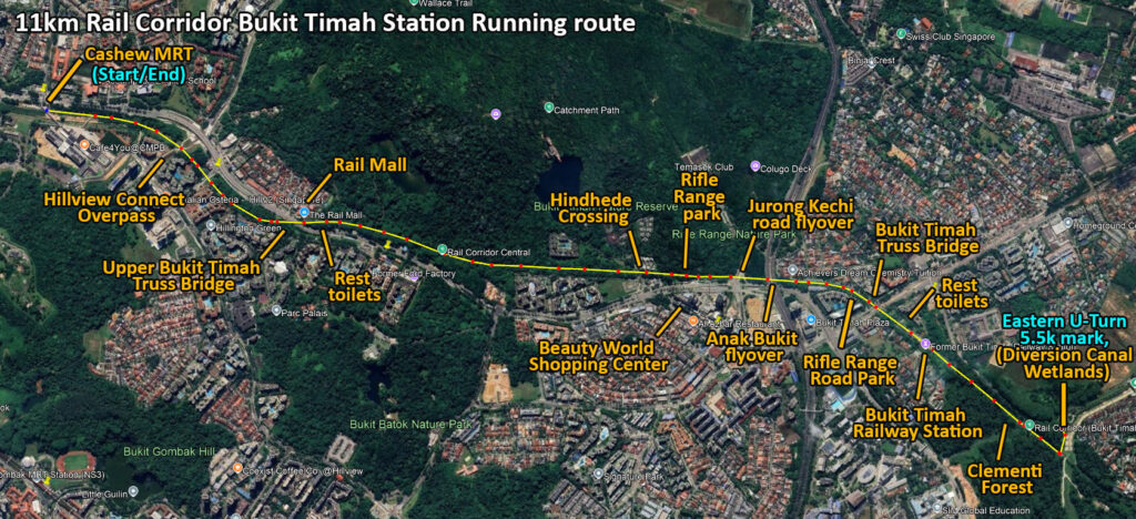
Our runs start off from Cashew MRT area taking a muddy dirt road towards the new Hillview Connect tunnel. Notably, the Hillview Connector links the Rail Corridor to Hillview MRT and nearby parks. You run through a shaded pathway lined with greenery.


This area is well-paved, making it easy for joggers and cyclists. The connector also passes residential blocks and commercial areas quietly tucked away from the main road. It feels like a small detour that blends nature with the urban edge.

Hillview Connect Overpass at Hillview Road
Moreover, this Hillview Connect Overpass carries the park connector safely above busy Hillview Road. Back on our previous run at dairy farm road, this Hillview Connect region was closed off for the construction of the vehicular road tunnel. Also, the road tunnel opening saw the park connector now running over the road tunnel which connects the road from Cashew MRT towards the Upper Bukit Timah Truss Bridge and Rail mall area.

It conveniently now links the Rail Corridor to the Hillview Connector without needing to navigate traffic. The overpass offers a clear view of surrounding condos and greenery. It has a functional but helps keep the running or cycling route continuous and easy.


Upper Bukit Timah Truss Bridge
The Upper Bukit Timah Truss Bridge is a black steel bridge spanning Bukit Timah Road. There are two similar truss bridges here, one at Upper Bukit Timah near the Rail mall and the second Rail Bridge near King Albert Park. Here you cross wooden planks that still hold their old railway bolts.

Historically, the bridge was built in the early 1900s and has been restored for public use. If you are sharp, you will notice a historical plaque sign placed at the entrance of the bridge. It is a popular photo stop thanks to its industrial, old-world look. From here, you can also spot nearby heritage shophouses and the flow of traffic below.

Moreover, the Upper Bukit Timah Truss Bridge area is home to a small rest and toilet area which sits beside the rail mall. It offers a nice shaded path if you need a break within the first kilometre of our route. The route from here carries on a long forested gravel straight for about a kilometre till our next point of interest.

Also, this flat route is also great for speed work, though do watch out for potholes and muddy water puddles after rain. Also, the route here is more suited for mountain bikes, and you might want to take caution riding road bikes here due to avoid punctures. There is a water stream running parallel at few points along this straight leading towards the Singapore Quarry Bridge.


Hindhede Crossing
You carry on past a minor Old KTM Railway Bridge at Hindhede Crossing. This small railway bridge sits quietly above Hindhede Drive at the 11.5km marker from Tanjong Pagar. You walk across its black steel frame, with wooden planks replacing the original rail sleepers.

The bridge once carried trains between Bukit Timah and Bukit Panjang. Today, it’s part of the Rail Corridor, offering a short-elevated view over the road. The structure keeps its weathered, industrial charm, adding a dash of history to your run or ride.


The route carries Beauty World Shopping Center. Beauty World is an older shopping complex near the Rail Corridor’s Bukit Timah stretch. You find small shops, eateries, and a food centre on the top floor. It is also a possible mid-way toilet stop, though quite far away.

The building has a retro 1980s look, with narrow walkways and low ceilings. It’s a tad worn, but still active with locals dining or shopping for daily goods. The area around it is packed with more modern malls, but this spot retains its old-school charm.


Rifle Range Road Park
Additionally, the route here is well forested, running alongside the Upper Bukit Timah road and passing by some resident condos left and right at the Hindhede estate area.

It is not long where the straight leads past from the Hindhede Crossing and eventually towards the entrance to the Rifle Range Road Park and the Seventh Mile Rail Corridor access route. Here, you can find connecting overhead bridges to Beauty world and the park entrance to the Rifle range road trail.

Notably, along the path, the Rifle Range Road Park is one of the newer green spaces linked to the Rail Corridor. You can enter the trail here from this Seventh Mile stretch. The park has open lawns, benches, and light landscaping. This part of the Rail Corridor is quieter compared to Bukit Timah Station. The access point is convenient for starting a jog or bike ride north or south along the trail.

The route carries on under the only two road flyovers of the route, under both the Jalan Jurong Kechi road and the Anak Bukit flyovers. Also here, you can find several wildlife along the route here, wild chickens such as the red jungle fowl are abundant here, especially along the Rifle range road area.

Monkeys, wild chickens and wild boars are less common and usually found coming out from the vegetated areas near the quarry area.


Running on, you cross over the Bukit Timah Truss Bridge at our 4km mark. It runs over the busy King Albert park area before heading into the major landmark of our route, the Bukit Timah Railway Station.


Bukit Timah Railway Station
The last landmark towards the 5.5km U-turn point of our run be the Bukit Timah Railway Station. This iconic red tiled shelter is a landmark along the Rail Corridor was restored as a heritage landmark. Here, you see preserved station buildings, old railway tracks, and old style retro signboards.

The place once served as a key stop on the Singapore–Kranji railway line under KTM. It closed in 2011 when train services shifted to Woodlands. Today, it works as a rest stop for joggers, cyclists, and walkers exploring the corridor.


Moreover, the first thing that catches your eye was the preserved platform and tracks. Here you can find some old railway cars permanently affixed onto the rails. The station building still stands, and inside. There is seating, shade, and boards telling the station’s history. It is small but worth a short pause if you’re running or cycling the route.


Also, the railway waiting house has a minor exhibition, albeit rather run-down. Here you can find restored fixtures like the old levers, a ticket booth, and even a signals diagram. It felt a tad surreal seeing how much of the place has been kept intact.


Scenes of the old railroad
Here, you can find fenced up old buildings of the Former Railway Staff Quarters. Also, the waiting area with a series of maps is simple but gives you a sense of how passengers once sat around for trains.

Across the tracks, the old staff quarters stood vacant, which was once turned into a café during the refurbishment. Now closed, some vintage details remain. It is a convenient spot to take a short break from your run.


Around the station grounds are repurposed pieces from the past, like token poles and old signs put up for display. Even the small yellow wagons on the tracks are more than decoration. There are also preserved rail signal signs kept by the station as well as benches with hand rails spaced meter apart, having a nod to the meter-gauge width of the tracks which is the standard used for the tracks here.

Also, this spot is where you can find your second toilet and water point beside the truss bridge. It is similar to the one at the rail mall in terms of design and span.


Clementi Forest & Bukit Timah Diversion Canal Wetlands
Carrying on east bound form the railway station brings us along a short 800m through the Clementi Forest. This area is lush secondary rainforest with several tall mature trees, with several mature over growth coming alongside the running trial.

Also, you can find lots of banana and durian trees along this route too. The air in this area is fresh and one of the wilderness highlights of the route.

It is not long where you come to the Bukit Timah Diversion Canal Wetlands park entrance. This small minor park serves a private estate here with a huge storm drain. It is accessible via a side detour from the main path.

Here you can find a is a series of stepped canals, also called the Maisy Falls. They are a series of Man-made cascading water falls, tad like terraced water channels that slow down water flow. The design mixes flood control with a touch of natural landscaping.

Here, birds and small fish are often visible if you stop to look closely. This spot feels a tad hidden but offers a break from the rail trail’s straight path. This spot marks our 5.5km U-turn point from the Cashew area, where our route back to where we started brings the total running distance to 11km.


Wrapping up
All in all, you are good for about just over an hour to and fro on this this 11km run. The route. Wrapping up the trail, the stretch along the Rail Corridor had a good mix of history and nature. Starting from Cashew MRT, the route moved through greenery, past the old railway bridge and tracks, with the highlight being the Bukit Timah Railway Station and lush Clementi Forest, where the preserved fixtures and displays tied the walk back to its railway roots. This running route is definitely a scenic and educational one, tad a simple way to see how old spaces were given new life.