The newly launched Walking Trails @ CDC is an innovative “phygital” initiative by the five Community Development Councils (CDCs). It is done in collaboration with Government Technology Agency (GovTech) of Singapore to promote community engagement. This encourages an active lifestyle by blending exercise with digital gamification. Let’s take an explore completing the North West route of the Walking Trails.

Moreover, each walking Trails @CDC are curated to showcase local heritage, green spaces, and civic landmarks. This North West CDC route we are doing is the longest of the 5 CDC walking trial routes. Coincidentally, this 5.5km North West route we are doing today follows closely our last exploration of the Bukit Timah rail corridor run we did sometime back.
Notably, the completion of each of the 5 trails in the program allows you can earn up to $10 worth of free CDC vouchers which you can be redeemed via RedeemSG. This means, you can earn up to $50 worth of CDC vouchers completing all 5 route all around Singapore. This comprises of $5 after completing all 5 checkpoints per trail, and an additional $5 when you collect 5 CDC Ollies owls along each trail.
The North West CDC route and other routes
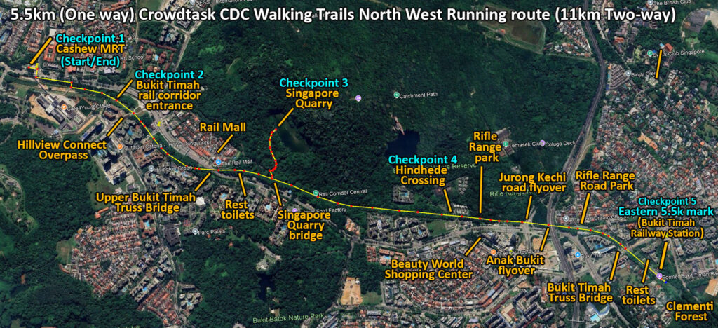
In a nutshell, the 5.5km one-way route starts from the Walkway outside Cashew MRT, and ending at the old Bukit Timah Railway Station, with and approximate distance of 5.5km. There are MRT stations at both the start (Cashew) and end points (King Albert park). It follows very closely to our previous explorations of our 11km Bukit Timah Rail coordor run as well as our exploration of the Dairy Farm and wallace trail area.
Highlights vary by district with each route is intentionally scenic and educational. Notably, the other 4 trails are firstly the 4.7km Central Singapore route features historical shophouses and Fort Canning’s parkland, with start point at Kreta Ayer Square and ending at Fort Canning Centre.
Secondly, there is the 4.5km North East CDC route starting at Punggol Waterway Point features and ending at the new Punggol Digital District. The 4.9km South East CDC route starts from Fort Tanjong Katong with Siglap Canal Lookout Deck being the end point. And lastly, there is the shortest of the bunch, a 4.35km South West route with start point starting from the nearby Beauty World MRT Exit C, and ending at the Little Guilin in the Bukit Batok area.
Setting up for your trail walk
To start, you register on CrowdTaskSG with Singpass first. This associates your account to credit your CDC vouchers. Thereafter you can explore the portal and select your desired trail on mobile for you to review the five checkpoint locations. Notably, the platform is mobile-first and requires you to start the quest from a phone. Also, as the entire app runs completely on your browser, so do remember to grant the website both location and camera permissions to your phone browser when prompted.

Furthermore, the walks are mostly friendly to most fitness levels. It is especially good for anyone wanting a low-effort way to discover local sights. Moreover, you can also complete the trail as part of a run. I paced myself to enjoy sights rather than rush. Expect roughly an hour and a half at a steady pace. You might be good for just under 2 hours for a slow walking pace and under and hour for a run/walk run pace.


Also, the web-app uses both your camera to check-in into each of the 5 checkpoints where you be presented a quiz question to answer at your point of interest. It is not difficult to answer them. Tasks at checkpoints are straightforward involving you to take a photo of a landmark, answer a short quiz, or tap to register presence.
Usually, the answer can be found right where you are. It is either hidden through visual observation or on signs and information signboards at your point of interest. Completing one brings you to the next checkpoint and unlocks part of the trail badge. Do note you cannot stop halfway and continue beyond day, and have to restart from the first checkpoint even you had checked into it previously.
Catch Ollie owl mascots
Moreover, a playful element of the programme is the CDC Ollie mascots. The digital ollies appear randomly on your trail map. It is part is tad synonymous to finding Pokémon’s on your journey. There are 5 unique different ollies to catch. These small digital characters appear on the map and can be “caught” for bonus rewards.

Also, fret not if your Ollie flew away after you try to catch one. Random new Ollies will pop-up along your route. Similarly, as said, the benefits of finding Ollies includes being awarded $5 CDC vouchers when you collect all 5 on your route. You also get $5 to complete all 5 checkpoints on your route itself, totaling $10 of RedeemSG vouchers, subject to availability.


Checkpoint 1- Cashew MRT Station, a civil defence shelter
Cashew MRT Station is our first stop and point of entry. The station opened in 2015 on the Downtown Line, sits near the Bukit Panjang area. It serves as a convenient gateway to the Rail Corridor to improve accessibility to the north-western part of Singapore. Also, it stands close to military landmarks like the former Bukit Timah Camp (which served the British), and also serves a civil defence public shelter. For the CDC trail, this marks an ideal starting checkpoint, symbolising how modern infrastructure connects communities to natural and heritage sites.

Also, I found the trail is a tidy way to explore familiar neighbourhoods differently. The programme blends physical trails with short digital tasks, and rewards walkers who complete five checkpoints on a route. It felt like a deliberate attempt to make neighbourhood walks more engaging and informative.
Checkpoint 2- Hillview Rail corridor
Moreover, the checkpoint 2 route brings you along upper Bukit Timah road. You cross the road here via traffic lights or overhead bridge into the Rail Corridor route proper. Interestingly, the Rail Corridor is a 24-kilometre green trail in-totality that once carried the Malayan Railway (KTM) trains linking Singapore to Malaysia.

After the tracks were decommissioned in 2011, the route was redeveloped as a continuous nature and heritage corridor. Today, it serves as a recreational path for walkers, cyclists, and heritage enthusiasts. On the CDC trail, it represents continuity, blending history with active lifestyles in a scenic walking route.


Checkpoint 3- Singapore Quarry home to kingfishers
Going along the rail corridor east-bound past the Hillview connect tunnel brings you over the Upper Bukit Timah truss bridge and into a long gravel straight leading to the Singapore Quarry.

Furthermore, the Singapore Quarry, once an active granite quarry, is now a tranquil wetland habitat located near Dairy Farm Nature Park. Mining ceased in the late 1980s, and the site was rehabilitated into a nature reserve, rich with bird life and lush greenery. Today, it is a peaceful spot for wildlife observation and leisure and home to several blue kingfishers. Within the CDC trail quest, it highlights Singapore’s transformation from industrial use to green conservation, offering participants a scenic checkpoint.

Here, you make a detour from the rail corridor route into a small flight of steps by the side of the path. These stairs bring you up to the Singapore quarry bridge over the path below. Interestingly, there a crossed-out danger sign greeting you at the start of the bridge. The small bridge looks well-built and solid, standing the test of time serving the quarry in haulage. Today it stands strong, albeit bit grimy and overgrown with vegetation all around it.


Crossing the bridge over the rail corridor brings you into a small vegetated clearing. You do need some bashing with some muddy patches. Still, the trail path here is well-worn out so you would not get lost here, soon after a short 20m walk through the vegetation, you hit the upwards service tarmac road to the quarry. Do note the quarry closes at 6:30pm daily, so do factor that in your visit.


Checkpoint 4- Hindhede Crossing old KTM Railway Bridge
Notably, the routes up and from the Singapore quarry was littered with Ollies to catch. This made catching all five different birds by the 2nd checkpoint very doable. When you complete a set, all future Ollies new positions are all greyed out and completed your five-Ollie collection for this route. Also, from the quarry, it is a long straight. You can simply run this stretch with your phone stowed for a nice uninterrupted run. If you had not caught all your Ollies.

Additionally, the old KTM Railway Bridge at Hindhede Crossing is a remnant of the former Malayan Railway line. Built to support trains traveling southward toward 11.5km from here to Tanjong Pagar railway station. Here, it retains its rustic steel structure as a heritage marker. Although no longer in use, it remains a photogenic landmark and reminder of Singapore’s transport past. For the CDC trail, it acts as both a visual highlight and a nod to the country’s railway history.
Final Checkpoint 5- Bukit Timah Old Railway Station
Our last and final check point along the route is the Bukit Timah Old Railway Station. Built in 1903, the Railway Station was once an important stop for trains on the Singapore to Malaysia route. Decommissioned in 2011, it has since been conserved as a heritage site with restored station buildings and a short stretch of track. Today, it is a popular spot for photography and history lovers. The area here is also family friendly. It is not uncommon for entire groups to complete the journey together.

Additionally, on the CDC trail, the old Bukit Timah Old Railway Station serves as a meaningful endpoint. It tad anchors the walk in heritage and connecting past transport links with present community recreation. Also, an informative sign by the toilet near the Truss bridge and the meter-wide arm rests on the benches here pays homage to the meter-gauge tracks used on the railway here.

Interestingly, at this spot, my total GPS distance came in at about 5.6km, just a tad more than the official 5.5km. This could be due to GPS drift and additional distances covered exploring the nooks at each point of interest.


Wrapping up
Lastly, in summary, the route does require going over a mix of gravel trails, off road muddy paths, so do wear sensible shoes, bring water, and check the CrowdTaskSG page for any notices or downtime before you leave. Rewards are limited to eligible residents aged 15 and above, and vouchers are distributed while stocks last. The trails are OT-OT (on-your-own-time), so you can plan around your schedule. Also expect that some Ollies can disappear from the map if many users catch them before you do.


Do bring a power bank if you expect your phone to run dry. Continuous use of GPS does put a drain on your phone, on my run with nearly continuous screen usage except on long running straights, my exploration used up 20% battery drain, for a total run journey of about 45 minutes, to an hour.
All in all, that wraps up our exploration of Crowdtask CDC Walking Trails @CDC. I found completing all five checkpoints rewards you beyond the vouchers. It allows you to explore new areas, notice small neighbourhood details, and pick up bits of local history your did probably skip otherwise. For anyone keen on a short, structured activity, the programme offers a neat mix of exercise, learning, and a little incentive. Plus, you can even catch a few Ollie owls along the way, which adds a light-hearted touch to the walk.